
Weather
Video Shows Severe Dust Storm Approaching Chicago and Western Suburbs
CHICAGO, IL — A significant dust storm is advancing toward the Chicago metropolitan area, with suburbs west of the city expected to experience reduced visibility and hazardous travel conditions.
Earlier this afternoon, portions of east-central and eastern Illinois were impacted by the same dust storm system, which developed due to strong wind gusts sweeping across dry, open terrain.
Video footage shared by residents and storm spotters shows large clouds of dust engulfing roadways, creating near whiteout conditions in some areas.
- Visibility may drop rapidly to near zero, especially along open highways, farmland, and rural roads.
- Drivers are urged to use extreme caution and avoid travel if possible as the storm approaches.
- If caught in a dust storm while driving, officials advise pulling off the road as far as safely possible, turning off lights, and keeping your foot off the brake pedal to avoid being rear-ended.
- Those with respiratory conditions, such as asthma or COPD, are encouraged to stay indoors and limit exposure to airborne dust particles.
The National Weather Service is monitoring the situation and may issue advisories or warnings as conditions evolve.
Residents across the greater Chicago area should remain alert and be prepared for sudden changes in visibility and air quality as the storm progresses.
Stay tuned to local weather alerts and trusted news sources for the latest updates.


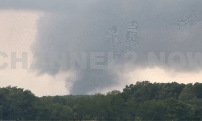


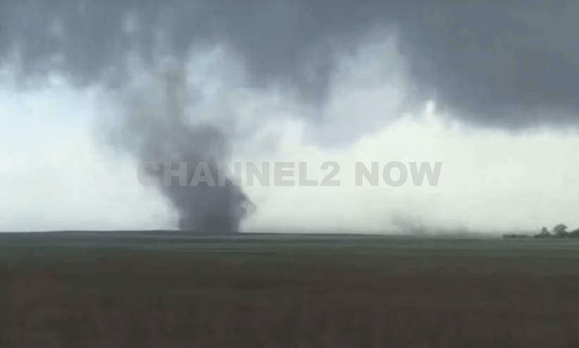
DENVER, CO — The National Weather Service (NWS) in Denver has issued a Tornado Warning for southwestern Logan County and north-central Washington County in northeastern Colorado, effective until 5:45 p.m. MDT Friday.
At 5:11 p.m., weather spotters confirmed a tornado on the ground near Merino, approximately 11 miles southwest of Sterling, moving southeast at 20 miles per hour.
The storm system is producing a dangerous and damaging tornado, with the potential for:
- Flying debris posing serious risk to those outdoors or in vehicles
- Structural damage to homes, roofs, windows, and vehicles
- Uprooted trees and downed power lines
- Total destruction of mobile homes
Communities directly in the path of the tornado include:
- Merino
- Prewitt Reservoir
- Atwood
- Logan Corners
- Willard
- Messex
Residents in these areas should seek shelter immediately. The safest option is to move to a basement or an interior room on the lowest floor of a sturdy building, away from windows and exterior walls.
Do not attempt to outrun the tornado in a vehicle. If no shelter is available, lie flat in a low-lying area and protect your head.
This is a confirmed tornado, not just radar-indicated. Immediate action is critical to ensuring safety.
Continue monitoring local media, NOAA weather radio, or official NWS alerts for real-time updates.