
Weather
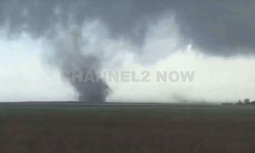
Tornado Hits Lake Mary Area North of Orlando

Orlando, Fla. – Severe storms swept through Central Florida on Monday morning, bringing heavy rain, strong winds, and multiple tornado warnings across the Orlando area.
A radar-confirmed tornado touched down along Interstate 4 in Lake Mary at approximately 9:30 a.m., causing structural damage, downed trees, and power outages. Officials report that around 3,500 residents are without power as a result of the storm.
West of Lake Mary, storm-related damage was reported at the Sweetwater Clubhouse tennis courts north of Wekiva Springs Road, where trees were downed.
Further damage assessments are underway in surrounding areas.
Seminole County Fire Rescue confirmed that emergency crews were assisting with storm damage along the 2100 block of Blue Iris Place.
According to meteorologist Noah Bergren, preliminary assessments suggest that the tornado was likely an EF0 or possibly a brief EF1, with estimated touchdown near Lake Mary Boulevard on the city’s west side.
Seminole County Emergency Management spokesperson Alan Harris reported multiple instances of structural damage, including a collapsed home and overturned vehicles.
Additionally, downed trees and power lines have made several roadways impassable.
As of Monday morning, no injuries had been reported. However, authorities continue to urge caution as cleanup efforts begin.
“Do not go outside right now,” Harris advised in a public statement. “Stay in your home or business until conditions improve.”
The tornado formed as a result of an intense storm system moving across Central Florida, which brought heavy downpours, gusty winds, and the potential for additional tornado activity.
Meteorologists anticipate that the storms will move quickly through the region, with rainfall expected to taper off by early to mid-afternoon.
A Tornado Watch means that conditions are favorable for the development of tornadoes and severe thunderstorms.
It does not guarantee that a tornado will occur but serves as an alert for residents to remain vigilant.
According to the National Weather Service (NWS), a severe thunderstorm is classified as one that produces winds of 58 mph or higher and/or hail measuring one inch in diameter or larger.
Officials continue to monitor weather conditions and encourage residents to stay informed through local news outlets and emergency alerts.


DENVER, CO — The National Weather Service (NWS) in Denver has issued a Tornado Warning for southwestern Logan County and north-central Washington County in northeastern Colorado, effective until 5:45 p.m. MDT Friday.
At 5:11 p.m., weather spotters confirmed a tornado on the ground near Merino, approximately 11 miles southwest of Sterling, moving southeast at 20 miles per hour.
The storm system is producing a dangerous and damaging tornado, with the potential for:
- Flying debris posing serious risk to those outdoors or in vehicles
- Structural damage to homes, roofs, windows, and vehicles
- Uprooted trees and downed power lines
- Total destruction of mobile homes
Communities directly in the path of the tornado include:
- Merino
- Prewitt Reservoir
- Atwood
- Logan Corners
- Willard
- Messex
Residents in these areas should seek shelter immediately. The safest option is to move to a basement or an interior room on the lowest floor of a sturdy building, away from windows and exterior walls.
Do not attempt to outrun the tornado in a vehicle. If no shelter is available, lie flat in a low-lying area and protect your head.
This is a confirmed tornado, not just radar-indicated. Immediate action is critical to ensuring safety.
Continue monitoring local media, NOAA weather radio, or official NWS alerts for real-time updates.