
Weather
Woman and her 7-year-old daughter died in Hart County flash flooding, child identified

HART COUNTY, KY – A woman Amy Philpott and her 7-year-old child, Charlotte Philpott, tragically lost their lives after their vehicle was swept away by flash flooding in the Bonnieville community of Hart County on Saturday night, authorities confirmed.
According to Hart County Coroner Tony Roberts, emergency responders from Campbellsville and Hart County were dispatched to Campground Road near Bacon Creek following reports of a water rescue.


Despite their best efforts, rising floodwaters and hazardous nighttime conditions forced crews to halt rescue operations before they could safely retrieve the victims and their vehicle.
Rescue teams recovered the child’s body from the submerged vehicle late Saturday night, but efforts to locate the mother had to be suspended until conditions improved.
On Sunday morning, search teams resumed recovery efforts and successfully retrieved the mother’s body later in the day.
The National Weather Service (NWS) in Louisville reported that the tragic incident occurred around 10:30 p.m. Saturday, when the victims’ vehicle was overtaken by rapidly rising floodwaters.
The devastating floods have wreaked havoc across Kentucky, triggering over 1,000 rescues as emergency teams race to assist those stranded by rising waters.
At least eight fatalities have been confirmed so far, with officials warning that the death toll may rise as search-and-rescue efforts continue.
“This is one of the most serious weather events we’ve dealt with in at least a decade,” Kentucky Governor Andy Beshear stated on Sunday.
Victims have been reported in Hart, Pike, and Clay counties, with many fatalities involving vehicles caught in floodwaters. Gov. Beshear urged residents to avoid driving in flooded areas to prevent further loss of life.
In Clay County, officials confirmed that a 73-year-old man was found dead in floodwaters, according to Revelle Berry, Deputy Director of County Emergency Management.
Widespread Impact Across the State
- Nearly 40,000 residents remain without power.
- 9,800 service connections are currently without water.
- 26,000 residents are under a boil-water advisory.
- Pike County School District announced indefinite school closures due to the disaster.
On Sunday, Gov. Beshear announced that President Donald Trump had approved his request for federal disaster relief funding to assist impacted communities.
Parts of Kentucky and Tennessee were inundated with up to six inches of rainfall over the weekend, according to Bob Oravec, senior forecaster at the National Weather Service.
“The effects will continue for a while—a lot of swollen streams and a lot of flooding still happening,” Oravec warned. “Even when the rain stops, floodwaters can linger for much longer.”
In addition to the devastation in Kentucky, officials confirmed that a levee in Rives, Tennessee, failed Saturday afternoon, flooding nearby neighborhoods. The extent of the impact remains unclear, and authorities are continuing to assess the damage.
Authorities are urging residents to remain cautious, avoid flooded roads, and follow local emergency guidelines as rescue and recovery efforts continue.


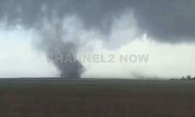
DENVER, CO — The National Weather Service (NWS) in Denver has issued a Tornado Warning for southwestern Logan County and north-central Washington County in northeastern Colorado, effective until 5:45 p.m. MDT Friday.
At 5:11 p.m., weather spotters confirmed a tornado on the ground near Merino, approximately 11 miles southwest of Sterling, moving southeast at 20 miles per hour.
The storm system is producing a dangerous and damaging tornado, with the potential for:
- Flying debris posing serious risk to those outdoors or in vehicles
- Structural damage to homes, roofs, windows, and vehicles
- Uprooted trees and downed power lines
- Total destruction of mobile homes
Communities directly in the path of the tornado include:
- Merino
- Prewitt Reservoir
- Atwood
- Logan Corners
- Willard
- Messex
Residents in these areas should seek shelter immediately. The safest option is to move to a basement or an interior room on the lowest floor of a sturdy building, away from windows and exterior walls.
Do not attempt to outrun the tornado in a vehicle. If no shelter is available, lie flat in a low-lying area and protect your head.
This is a confirmed tornado, not just radar-indicated. Immediate action is critical to ensuring safety.
Continue monitoring local media, NOAA weather radio, or official NWS alerts for real-time updates.