
Weather
Hurricane Milton is now forecast to become an extremely dangerous Category 4 before landfall in Florida
Hurricane Milton has undergone rapid intensification, prompting concerns for coastal regions in Florida and Mexico.
Forecasters upgraded Milton from a tropical storm to a hurricane a day earlier than predicted, and it is now expected to strengthen to Category 4 within the next two days.
Currently churning in the Gulf of Mexico with sustained winds of 85 miles per hour, Milton is approximately 805 miles away from Tampa as of Sunday 5 PM ET.
The Mexican government has issued a hurricane watch for the north coast of the Yucatán peninsula, anticipating a storm surge of up to 4 feet.
Rainfall from Milton is expected to be significant, ranging from 5-8 inches across portions of the Florida Peninsula and the Keys through Wednesday night.
This rainfall could lead to flash flooding, urban flooding, and minor to moderate river flooding.
A Flash Flood Watch is in effect for the Florida Peninsula starting Sunday morning. Additionally, a wave of moisture ahead of Milton will bring tropical downpours to the region beginning on Sunday.
While not a complete washout, localized areas could experience heavy rainfall leading to flash flooding.
Areas south of Interstate 4 are particularly vulnerable to significant rainfall due to a front sinking in from the north. Coastal regions should closely monitor weather forecasts and be prepared to receive flash flood warnings.
The anticipated rainfall from Sunday night to Wednesday is expected to range from 3 to 6 inches, with potentially higher totals in isolated areas.


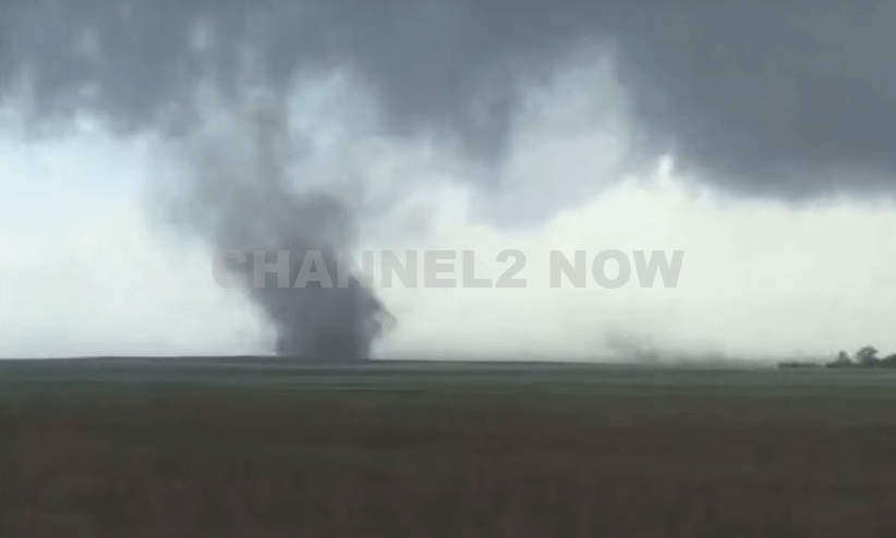
DENVER, CO — The National Weather Service (NWS) in Denver has issued a Tornado Warning for southwestern Logan County and north-central Washington County in northeastern Colorado, effective until 5:45 p.m. MDT Friday.
At 5:11 p.m., weather spotters confirmed a tornado on the ground near Merino, approximately 11 miles southwest of Sterling, moving southeast at 20 miles per hour.
The storm system is producing a dangerous and damaging tornado, with the potential for:
- Flying debris posing serious risk to those outdoors or in vehicles
- Structural damage to homes, roofs, windows, and vehicles
- Uprooted trees and downed power lines
- Total destruction of mobile homes
Communities directly in the path of the tornado include:
- Merino
- Prewitt Reservoir
- Atwood
- Logan Corners
- Willard
- Messex
Residents in these areas should seek shelter immediately. The safest option is to move to a basement or an interior room on the lowest floor of a sturdy building, away from windows and exterior walls.
Do not attempt to outrun the tornado in a vehicle. If no shelter is available, lie flat in a low-lying area and protect your head.
This is a confirmed tornado, not just radar-indicated. Immediate action is critical to ensuring safety.
Continue monitoring local media, NOAA weather radio, or official NWS alerts for real-time updates.