
Weather
Hurricane Helene Threatens Florida’s Big Bend Coast
Hurricane Helene, a Category 4 storm, is expected to bring devastating winds and storm surge to the Big Bend region of Florida on Thursday evening.
The National Hurricane Center has issued hurricane and storm surge warnings for parts of the state’s Gulf Coast, including the Tampa Bay area.
“Catastrophic” conditions are anticipated as Helene approaches, with the storm expected to intensify further before making landfall.
As of the latest advisory, the hurricane was located 80 miles west-southwest of Cedar Key, Florida, and moving north-northeast at 23 mph with maximum sustained winds of 130 mph.
The Tampa Bay area began experiencing the storm’s outer rain bands on Wednesday night, and the system’s parallel path to the region on Thursday led to significant impacts, including heavy rainfall, strong winds, and storm surge.
While winds are expected to shift out of the southwest on Friday, flooding and storm surge will remain major concerns.
Storm Surge Predictions:
- Citrus, Pasco, and Hernando counties: 6-15 feet
- Hillsborough County: 5-8 feet
- Manatee and Sarasota Counties: 4-7 feet
- Inland counties (Polk, Hardee, Desoto, and Highlands): 1-3 feet
Other Impacts:
- Rainfall: 4-8 inches possible
- Winds: Sustained winds of 45-55+ mph
- Severe Weather: Isolated tornadoes possible
Warnings and Watches:
- Storm Surge Warning: Mexico Beach eastward and southward to Flamingo, Tampa Bay, Charlotte Harbor
- Storm Surge Watch: West of Indian Pass to Mexico Beach
- Hurricane Watch: Englewood to the Anclote River, including Tampa Bay
- Hurricane Warning: Anclote River to Mexico Beach
Residents in the affected areas are urged to follow the guidance of local authorities and prepare for the potential impacts of Hurricane Helene.


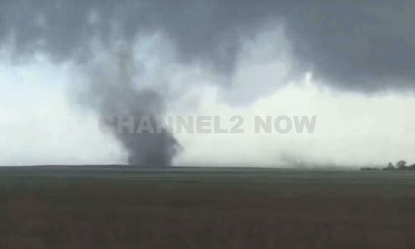
DENVER, CO — The National Weather Service (NWS) in Denver has issued a Tornado Warning for southwestern Logan County and north-central Washington County in northeastern Colorado, effective until 5:45 p.m. MDT Friday.
At 5:11 p.m., weather spotters confirmed a tornado on the ground near Merino, approximately 11 miles southwest of Sterling, moving southeast at 20 miles per hour.
The storm system is producing a dangerous and damaging tornado, with the potential for:
- Flying debris posing serious risk to those outdoors or in vehicles
- Structural damage to homes, roofs, windows, and vehicles
- Uprooted trees and downed power lines
- Total destruction of mobile homes
Communities directly in the path of the tornado include:
- Merino
- Prewitt Reservoir
- Atwood
- Logan Corners
- Willard
- Messex
Residents in these areas should seek shelter immediately. The safest option is to move to a basement or an interior room on the lowest floor of a sturdy building, away from windows and exterior walls.
Do not attempt to outrun the tornado in a vehicle. If no shelter is available, lie flat in a low-lying area and protect your head.
This is a confirmed tornado, not just radar-indicated. Immediate action is critical to ensuring safety.
Continue monitoring local media, NOAA weather radio, or official NWS alerts for real-time updates.